Screenshots of Volkswagen-Google Earth In-Car navigation system

The navigation system is equipped with a vehicle-centric touchscreen interface to Google Earth with state-of-the-art graphics, accurate 3D maps and real-time traffic updates and routing. Current information on restaurants, dealerships, gas stations and other points of interest can be overlaid directly onto the user’s 3D map. 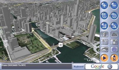
Driver and Passenger will be able to instinctively recognize where they are in relation to the surrounding topography, especially in urban areas that are depicted with depth and accurate size relationships between buildings and roads.

Source: Volkswagen Electronics Research Laboratory ERL | VW Mediaroom

0 comments:
Post a Comment