Who knows Indian security threats better - Google or The Indian Army ?
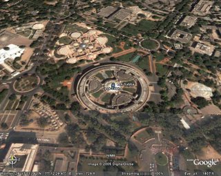
 The Indian Army Chief recently expressed concern over Google Earth's display of high resolution pictures of key Indian installations including military bases, offices of the Prime Minister and the President, as well as Indian Nuclear facilities.
However Google has downplayed Indian Army concerns and maintained that its satellite pictures of sensitive installations posed no threat to India.
Makes one think that Google, a search engine, has a better understanding of security threats to India than the Armed forces themselves. There's more - Google is even trying to sell Google Earth technology to the Indian government by showcasing that it was used during the Kashmir earthquake relief efforts.
Some of the remarks made by Google rejecting Indian concerns:
Google Earth is built from information that is already available from a wide range of both commercial and public sources. As such, Google Earth presents no appreciable threat to security, given the wide commercial availability of high-resolution satellite and aerial imagery of every country in the world.Google is already in talks with the Indian Goverment to dispel secruity concerns. It said anyone flying over sensitive sites can produce such pictures and no government has objected to the images so far.
Google's freely available technology has been used for vital purposes ranging from fighting forest fires to emergency response, rescue, and relief in natural disasters such as the Kashmir Earthquake relief efforts and the Mithi River Floodplain Project.The Indian Army is not convinced and may soon lodge a formal complaint with Google over its satellite images of key installations in India.
For the curious, here's a satellite picture of the Indian Parliament found on Google earth:

8:26 AM
|
|
This entry was posted on 8:26 AM
You can follow any responses to this entry through
the RSS 2.0 feed.
You can leave a response,
or trackback from your own site.
0 comments:
Post a Comment